
 The Canadian Crown of the Continent (CCoC), between Banff National Park and Glacier National Park at the US border, supports an assemblage of carnivores that is unique in North America for its intact diversity. Because of its particular geographic position, the CCoC also represents one of the most strategically important regions in maintaining ecological connectivity for carnivores and other wildlife in the Great Northern Landscape. The CCoC has been identified as crucial for wolverines north of the US border to supply individuals and genes through dispersal to the highly fragmented population in the northern US Rocky Mountains. The Canadian Rockies has been identified as a potential corridor for wolverine movement into the US and the most likely long-term prospect for transboundary wolverine habitat connectivity given climate change scenarios.
There is no empirical information on wolverine occupancy, population density, habitat linkages and genetic connectivity in the CCoC region. Coarse-scale models were used to identify core areas and potential connectivity. The lack of empirical, robust demographic and connectivity data to inform management is a growing concern given the increasing scale of landscape impact, and that wolverines are still legally harvested and impacted by two of the three main landscape stressors (land use and climate change) in the Great Northern Landscape.
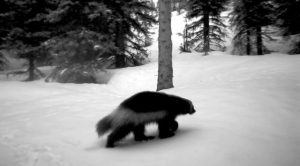
Remote cameras and noninvasive genetic sampling (NGS) are powerful tools to examine how human disturbance and landscape fragmentation affects species distributions, landscape connectivity, and gene flow. This research will add new sampling to achieve spatial contiguity within the Rocky Mountains and larger transboundary metapopulation shared between the US and Canada. Merging existing data with newly collected data, the research team will create spatially-explicit models of wolverine population size, occupancy, and connectivity.