New Study Identifies Potential Animal Highway Crossing Locations Across Western U.S.

Image of elk near entrance of a wildlife underpass
Elk approaches wildlife underpass in Banff National Park (courtesy of Tony Clevenger)

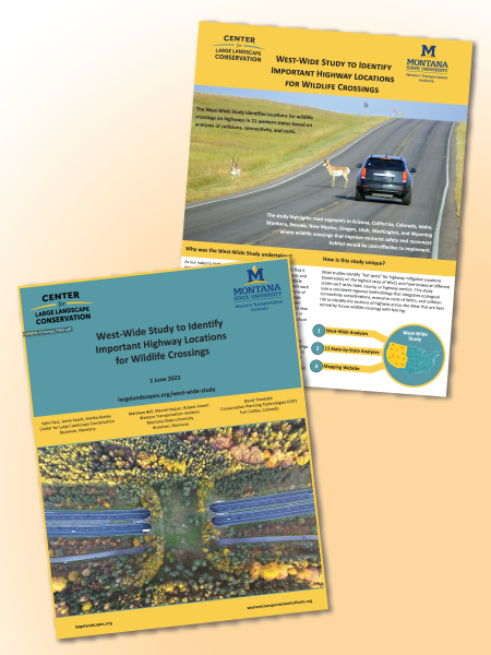
Increasingly busy highways and fragmented habitats have boosted the number of wildlife-vehicle collisions (WVCs) in the U.S. each year. Dangerous to both animals and humans, these collisions kill more than one million large mammals and hundreds of humans per year and cause tens of thousands of injuries. To begin addressing these collisions, the nonprofit Center for Large Landscape Conservation, Western Transportation Institute, and Dr. David Theobald with Conservation Planning Technologies have published the West-Wide Study to Identify Important Highway Locations for Wildlife Crossings. It pinpoints the highest rated road segments in 11 western states to consider for future wildlife crossings, which would offset collision costs, address conservation needs, and provide for human safety.

The study is also innovative, integrating ecological, economic, and safety considerations rather than choosing locations based on WVC hotspots alone when considering highways across the West. It is also one of the first studies to look at all western states with a consistent, regional approach – allowing for state-to-state comparison. The study is designed to complement and supplement state-wide and local analyses that use finer-scale data, which helps federal and state agencies and other stakeholders focus on areas where wildlife crossings can be deployed.

According to the study’s findings, WVCs with species like deer cost a minimum of $1.6 billion per year in the western U.S. It also identifies potential wildlife crossing structure locations that could not only mitigate impacts to human and animal safety but entirely offset the cost of WVCs by driving down crash rates and their cost to society.

The study comes at a time of increased interest, momentum, and policies for building wildlife crossings and implementing other mitigation measures in the U.S., including $350 million in federal funding from the Wildlife Crossings Pilot Program, part of the Bipartisan Infrastructure Law.

The three main components of the study are available online and include the full report containing both the West-wide analysis and 11 individual state analyses, plus a mapping website where users can examine the results at a variety of scales, select different map layers of interest, and download the data.

MSU Graduate Investigates Presence of Monarch Butterflies and Other Pollinators in Roadside Habitats

Monarch butterfly on orange flower
Source: MS Word Image Library

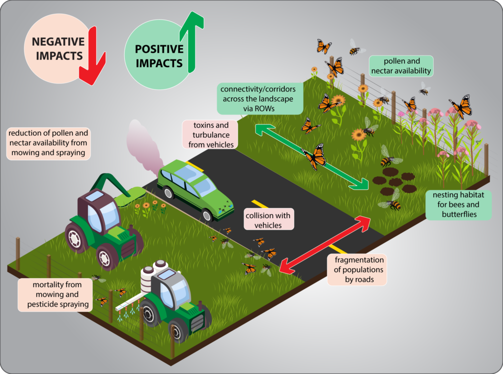
Monarch butterflies (Danaus plexippus), the striking and iconic orange and black insects of postcards and motivational posters, have been in population decline since the 1980s and Thomas Meinzen, a master’s student in Montana State University’s Ecology Department, turned to a largely overlooked environment to save them. His thesis, Bees and Butterflies in Roadside Habitats: Identifying Patterns, Protecting Monarchs, and Informing Management, investigated the value of highway rights-of-way (ROWs) for pollinator, especially monarch, conservation. Supported by the Idaho Transportation Department (ITD), the project evaluated undeveloped land that parallels many roads for its potential to sustain western US monarch migrations and determined the variety of other pollinator species that used its native and non-native plants.

Thomas was advised by MSU Ecology Department Head, Dr. Diane Debinski, a butterfly specialist, in partnership with fellow ecology professor Dr. Laura Burkle, a bee specialist, and WTI’s Road Ecology Program Manager, Rob Ament. He surveyed 910 miles of southeast Idaho highways for the presence of monarchs and identified the number and location of showy milkweed patches (Asclepias speciosa – the obligate host plant of monarch larva). Thomas also noted the abundance and variety of other butterflies, bees, and native and non-native plants found in the roadside habitats.

The researchers were surprised to find that showy milkweed was quite common along SE Idaho highways, while monarch butterfly numbers had decreased alarmingly in 2021 and 2022. They were also surprised that bee variety and quantity was higher in secondary highway roadsides compared to primary and interstate ROWs, as well as areas dominated by native plants.

“Our study found that areas with diverse native flora and sagebrush steppe, in particular,” said Dr. Debinski, “had significantly higher bee richness and abundance than other sites.” At the same time, the abundance of butterflies depended almost entirely on the number of flowering plants, native or not.

The field study also developed roadside management recommendations to help insects overcome the downside of living and breeding in the ROWs. “Collisions with vehicles, pollutants, herbicides, insecticides, and disturbance caused by management practices were all hazards associated with bee and butterfly use of roadsides,” explained Dr. Debinski. “One of the goals of this research was to understand the best way to manage those areas for pollinators.” This is particularly true for monarchs, which are experiencing critically low population numbers, cannot afford to lay eggs or have their larva feed on plants that will be cut or sprayed in the middle of their lifecycle.

“Bees and Butterflies in Roadside Habitats” expressed concern that roadside habitats could become traps, luring pollinators in with healthy ecosystems and then collapsing population numbers through highway management practices or pollution. To avoid creating a population sink, the report recommended a suite of good practices, from protecting all roadside milkweed patches from herbicides and mowing, mowing smaller portions of the ROW with less frequency and never after flowering, and using pollinator-safe mowers, to spot treating weeds rather than applying herbicides to the entire roadside.

Overall, the research revealed that land along southeast Idaho highways, particularly those with lower traffic levels, was supporting a wide variety of pollinators and could provide an important role in pollinator conservation. “This is one of those areas in road ecology that is finally receiving the attention it is due, particularly given 85% of all agricultural crops require pollinators,” commented Rob Ament.

However, further research is required. “We need to figure out if roadsides are contributing to pollinator population growth or decline overall,” noted Dr. Debinski. “Future research should also determine whether roadside habitats act as corridors for pollinator dispersal; a catchy idea, but one that needs support from more data.”

PROJECT NEWS: WTI Researchers Demystify the Salt Phase Diagram

Road salt, most often sodium chloride (NaCl) melts ice and is a crucial tool for winter maintenance crews around the world. However, the constant application of road salt is resulting in long-term environmental and economic impacts. To slow the negative effects of sodium chloride deicers by optimizing salt use, researchers from WTI and Washington State University completed Understanding the Salt Phase Diagram, a project sponsored by Clear Roads, a Federal Highway Administration (FHWA) pooled fund. Led by Laura Fay, WTI’s Cold Climate Operations and Systems Program Manager, the team completed a literature review and laboratory investigation of the NaCl phase diagram, a graphical representation of the physical states (liquids or solid salt/ice) of salt brine depending on concentration and temperature. They distilled the information into training materials to help winter maintenance practitioners better understand the salt phase diagram and to support efficient and effective roadway deicing.

To provide visual aids for the training materials, the researchers needed to demonstrate the behavior of salt solutions in a laboratory setting. They collected video and photographic evidence of ice formation in salt brine at a range of concentrations and temperatures, verifying the familiar process of lowering ice’s freezing point with the addition of salt. They also clarified the effects of high salt concentrations on ice formation.

By synthesizing their laboratory data, the researchers created an updated NaCl phase diagram, fact sheet, and accompanying video. WTI’s Visual Communications Manager, Neil Hetherington, ensured that the phase diagram was associated with easily recognizable design elements (e.g., green = good = ice prevention). Fay noted, “Neil [Hetherington] took subject matter that was science and engineering heavy and converted it into useful, digestible information that is easily transferable. He also took time to collect quality photographs which effectively conveyed the information.”

The research has been well received. Fay has presented the training materials and findings to multiple organizations. “These materials serve as powerful education tools,” noted Fay, “and they are being used across the country.”

The full report is available on the project webpage of the WTI website.  The video may be found here: https://www.youtube.com/watch?v=xzrvOoJGH_w

PROJECT News: Scan of Communities with Fewer than 10,000 People finds Biking/Walking to be “Wheelie” Popular

Walking and bicycling have become increasingly popular transportation modes as people consider the positive impacts of active living. While there are examples of large, urban areas driving the implementation of infrastructure to support these modes within their jurisdictions, communities with populations smaller than 10,000 people may have limited infrastructure and know-how. Since 84% of communities in the United States are home to 10,000 people or fewer, these geographically distributed communities can have big impacts on transportation trends.

To investigate multimodal transportation options in these small towns, WTI researchers Natalie Villwock-Witte and Karalyn Clouser conducted Case Studies of Communities of Less than 10,000 People with Bicycle & Pedestrian Infrastructure. Funded by five state departments of transportation and the Small Urban, Rural and Tribal Center on Mobility (SURTCOM), the project examined 15 communities across five states (Florida,  Kentucky, Minnesota, New Mexico, and Vermont).

Researchers traveled to each community to conduct on-site research on existing infrastructure and interact with community members. They collected geo-located photographs and data on active transportation infrastructure and condensed this information into infrastructure maps, conducted interviews, and provided on-site survey distribution. “For rural areas, in-person contact is key,” noted Villwock-Witte. “Local buy-in had a dramatic impact on data collection.”

The resulting case studies for each community highlight examples of active transportation infrastructure and outline characteristics that lead to a successful bike/walk culture. Also, the final report synthesizing all the case studies can provide guidance for other small communities. “These case studies,” said Villwock-Witte, “show that [bicycle and pedestrian infrastructure] does exist and describe how small communities across the U.S. have put it in place. The selected case studies are not the exception to the rule.”  As existing infrastructure, such as state highways through small towns, is reimagined, communities will look to their peers for inspiration noted Villwock-Witte. “I see lots of opportunities to build on this work in the near future and for many years to come.”

The case studies and final report are available on the project page of the WTI website

PROJECT NEWS: Tools and Strategies for Developing Severity Indices

snow plow drives on snowy 2 lane highway through forest

The Clear Roads research program, which sponsors practitioner-focused winter maintenance research, is highlighting a recently completed severity index project on its website. For “Evaluation of SSI and WSI Variables,” the Narwhal Group and WTI collaborated to create a step-by-step guide to support implementing a severity index, paired with a flowchart tool that helps match users with existing indexes.

These tools will help winter maintenance agencies select the most appropriate storm severity index and winter severity index to compare storms across more than one winter season. “While a number of severity indexes exist, determining if you can apply or modify one for your needs or develop your own can be a daunting task. This guide and flowchart tool will support agencies in this task,” said Cold Climates Program Manager Laura Fay, who served as a co-PI. The final report is available on the WTI project webpage and there is a research brief on the Clear Roads project page.

NPS Plans Safety Improvements Based on WTI Study

Report Cover for George Washington Memorial Parkway Safety Assessment with photos of pedestrian and cyclists sharing road with vehicles

Along a historic parkway in Virginia, the National Park Service (NPS) will soon begin improvements to enhance safety for drivers, pedestrians, and cyclists.  In a recent news release, the NPS announced planned safety measures for the George Washington Memorial Parkway, which runs along the Potomac River near George Washington’s Mount Vernon Estate.  The Parkway serves recreational and tourism users, as well as a growing number of commuters, which has led to increased congestion and safety challenges.

The recommended improvements stem from a major safety assessment conducted by WTI and Mead & Hunt on behalf of the Eastern Federal Lands Highway Division (EFLHD) of USDOT. The GWMP Traffic and Safety Context Sensitive Solutions Assessment, led by Principal Investigator Natalie Villwock-Witte, studied traffic conditions and crashes at nine intersections on the Parkway, then developed individual recommendations for each. Proposed alternatives were designed to enhance safety, while maintaining the character of a national park setting. The full report is available on the project webpage.

Cyclist and pedestrian cross tree-lined parkway near vehicles

NEW REPORT: What is the Impact of a Local Gas Tax in Montana?

Map of Montana highlighting 7counties studied in fuel tax research: Missoula, Gallatin, Madison, Cascade, Hill, Fergus, and Garfield

As one source of funding for transportation projects, the federal government and all states place a tax on fuel purchases. However, at the local and regional level, authorization and use of fuel taxes vary widely.  In Montana, for example, state law has authorized a local option gas tax since 1979, but it has not been utilized.  That changed in June 2020 when voters in Missoula County approved a historic local option gas tax, marking the first time any county in the state has done so.

The success of the referendum in Missoula County may generate increased interest in this funding source by other counties.  In addition, there are ongoing discussions at the state and national level about the viability of fuel taxes as a sustainable funding resource in response to recent reductions in fuel consumption and in the context of the upcoming reauthorization of federal transportation legislation.  In light of all these factors, WTI recently completed a study to consider the revenues that could be raised for roads, highways, streets, and bridges throughout Montana by imposing the local option gas tax.

An Evaluation of the Montana Local Option Motor Fuel Excise Tax” summarizes the recent history of federal and state fuel taxes, with a focus on the State of Montana and Missoula County. The subsequent analysis assesses fuel tax revenues and expenditures for roads, highways, streets, and bridges for seven Montana counties (Cascade, Fergus, Gallatin, Garfield, Hill, Madison, and Missoula).  Several findings provide insights related to the contribution of fuel taxes to transportation expenditures; for example, neither state gas nor diesel taxes have kept up with inflation, and fuel tax revenues cover a relatively small share (7%-10% on average) of the roadway, highway, street, and bridge expenditures across the seven Montana counties in the study area. Moreover, the 2 cent/gallon local option tax is estimated to increase an average motorist’s costs by a relatively modest $8 – $27 per year. The full report, authored by Principal Investigator Andrea Hamre, is available on the project webpage of the WTI website.

NEW REPORT: Hot Spot Analysis of Large Mammal-Vehicle Collisions in California

Two deer crossing guard rail and road on Hwy 191 approaching Jackson Hole, WY.The final report is now available for a wildlife vehicle collision study conducted for the California Department of Transportation.  Road Ecology Research Ecologist Marcel Huijser and Research Associate James Begley authored the final report for “Large Mammal-Vehicle Collision Hot Spot Analysis,” which provides guidance on the implementation of mitigation measures aimed at reducing collisions with large wild mammals along all state managed highways in California, with an emphasis on mule deer. These analyses identified the road sections that had the “highest” concentration of deer-vehicle crashes and mule deer carcasses. The hot spots were prioritized based on parameters related to human safety, biological conservation, and economics. Finally, the researchers provided practical guidelines for the implementation of mitigation measures and suggest mitigation strategies for the highest-ranking hot spots in each Caltrans district.

The report is available on the Hot Spot Analysis project page of the WTI website.